Puget Sound Lidar Consortium

Home | About Lidar | About the PSLC | Data | Uses of Lidar data | Links | Contact us


2005 Lower Columbia River Projects


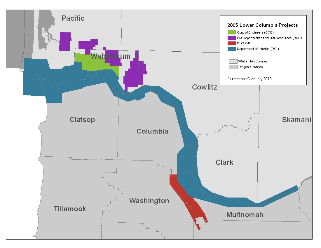
Description:
This project covers the lower Columbia River from Bonneville Dam to the Pacific Ocean.  The Project was funded by four different agencies, The Corp of Engineers (COE), Department of Natural Resources (DNR), Department of Interior (DOI) and The Oregon Department of Geology and Mineral Industries (DOGAMI).  The contractor that surveyed and processed the data separated it by funding agency.  The PSLC has merged all raster data in areas that have common boundaries.  The point ASCII data has been preserved in its original state.

The DEM grid cell size is six feet. The elevation units are in feet. The data is in Washington State Plane South Coordinate System FIPS 4602, in the NAD83(HARN)/NAVD88 datum.


Back to Data by Projects

Reference Information:
This information is provided to be used in conjuction with the LiDAR datasets.

Map of all Projects (JPEG)
Metadata

All-retun ASCII Header Information (.txt)
Project Reports
Trajectory Files
Project Area and Index files (Shapefile)
Frequently Asked Questions
      
Data:
The raster data is available in either USGS quarter quads and as a Mosaic.  The elevation data in quarter quads is in the
ArcInterchange .e00 format.  The hillshade images in quarter quad are in georeference TIFF format.  The raster elevation data is also available as a mosaic ArcGIS 9.x file Geodatabase.  The file Geodatabase includes raster datasets for the bare earth and the top surface. The point data is available in ASCII text format.  Point data is only available by tile.  A tile is a 1/25 section of a USGS quarter quad.  For details on the subdivisions of this data see the Index shapefiles in the Reference Information section above.

Raster Data by USGS Quarter Quad/Tiles Individual Files DEM Index Map Topographic Image
Index Map
Bare Earth - 6 ft raster resolution


Top Surface - 6 ft raster resolution


Raster Mosaic Data


File Geodatabase Mosaic


Bare Earth  ASCII Files
The bare earth ASCII data is available by individual project.  Adjacent areas have not been merged.  To search and download the data follow the steps below.  If you have further questions see the
Frequently Asked Questions page.

Download Steps
1.  Download the Project Coverage shapefile and the Tile Index shapefile.
2.  Using the Project Coverage shapefile find the PSLC project and the sub-project that covers your area.  If your area is on the boundary of two projects, you will need to download files from both.
3.  Using the Tile Index shapefile find the quarter quad(s) and tile(s) that cover your area.
4.  From the list below, select the project or sub-project you found in step 2.  Once there find the quarter quad(s) and download the tiles for your area (from step 3).

List of LiDAR Projects and Sub-Projects
PSLC2005
Lower Columbia River -  DOI
Lower Columbia River -  DNR
Lower Columbia River -  COE
Lower Columbia River -  DOGAMI
See also Yacolt State Forest for the eastern end.


All-Returns
ASCII
The 
All Returns ASCII data is available
by individual project.  Adjacent areas have not been merged.  To download the data follow the steps below.  If you have further questions see the Frequently Asked Questions page.  For field headers see the All-retun ASCII Header Information.

Download Steps
1.  Download the Project Coverage shapefile and the Tile Index shapefile.
2.  Using the Project Coverage shapefile find the PSLC project and the sub-project that covers your area.  If your area is on the boundary of two projects, you will need to download files from both.
3.  Using the Tile Index shapefile find the quarter quad(s) and tile(s) that cover your area.
4.  From the list below, select the link for the project or sub-project you found in step 2.  Once there find the quarter quad(s) and download the tiles for your area (from step 3).

List of LiDAR Projects and Sub-Projects
PSLC2005
Lower Columbia River -  DOI
Lower Columbia River -  DNR
Lower Columbia River -  COE
Lower Columbia River -  DOGAMI


Back to Data by Projects


Update Policy 
As we approve data from the contractor they are posted here. Areas within many of the bare-earth DEMs can be improved by further processing of the all-return point data to better isolate bare-earth points. As we make these improvements we will upgrade the bare-earth DEMs and derivative images posted here.

Technical Assistance
If you have difficulty loading the data files into your software, cannot easily transfer large files via the Internet, or would like advice on the uses and limitations of these data, please reference our frequently asked questions.  If you can't find what you need here contact us.

This page maintained by PSLC webmaster